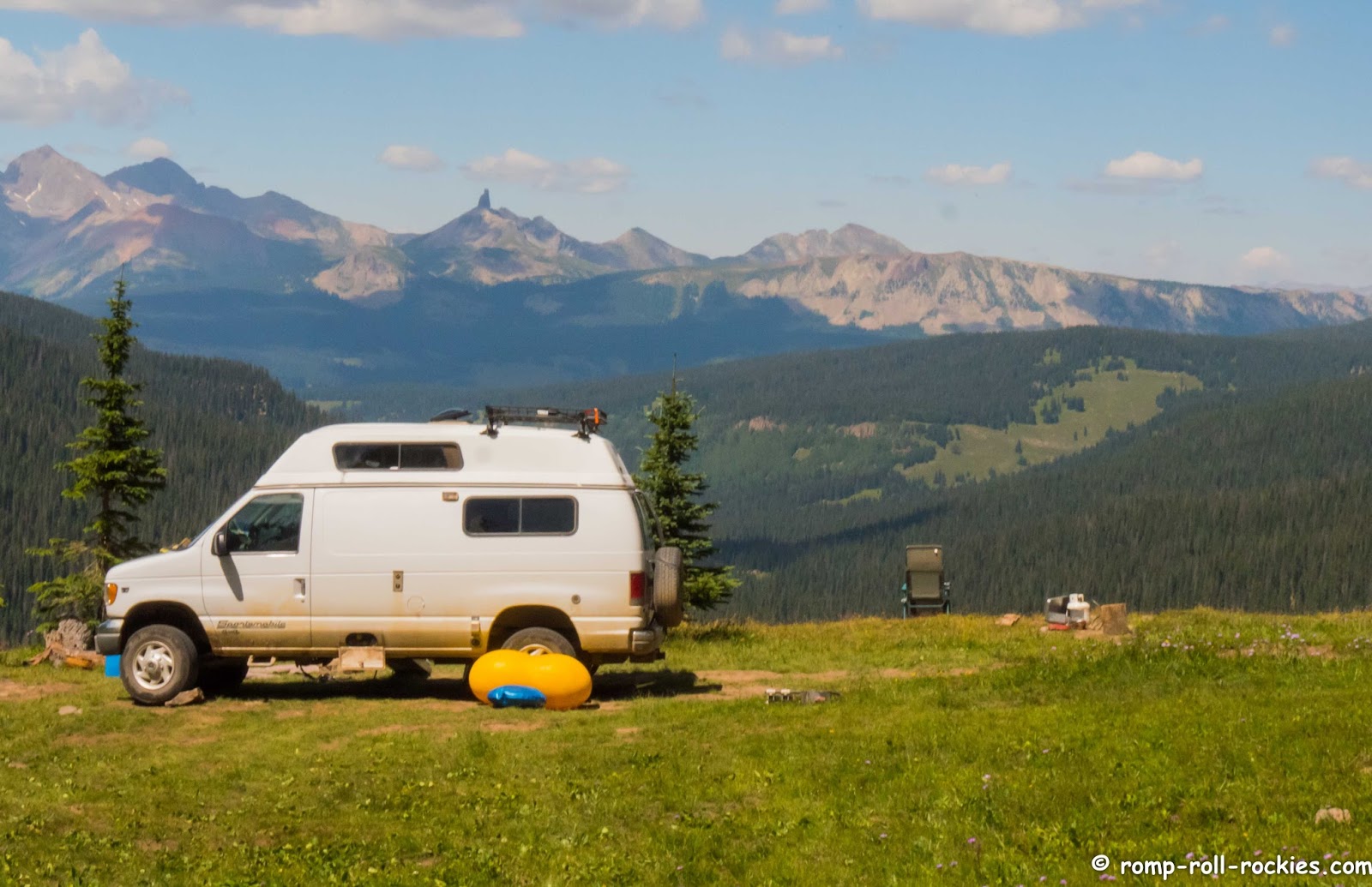
It's cold here in the Colorado mountains today. Feeling chilled while on my mountain bike reminded me of a day during our last summer vacation.
We awakened to sunny weather. We were surprised because we'd heard that storms were bearing down on our location that might even bring snow. For that reason, we'd decided to cut our time short at our high altitude campsite.
As I took off for my ride, I thought that we were making a mistake to leave so soon. Our campsite was warm and inviting.
My plan was to ride out to a high mountain pass, retrace my route, and then go down about 3,000' on a jeep road to meet the Runner and the Duo.
I set out full of energy for a great ride. Angry clouds invaded the sky quickly. However, I'd seen dark clouds over the mountains every single day that we'd been at this campsite, and no big storms had ensued.
In fact, I'd taken this photo from my "phone booth" the day before. It was the spot where I accessed an on-line course that I was taking (it was in the 50 yards of trail where I got good cell reception). I thought it was a spectacular spot to "work"!
On the day of my "departure ride", it looked less threatening than on other days. Sure, there were clouds, but none looked immediately dangerous.
Here's another view from that day about halfway to that high mountain pass I wanted to "tag" before heading down to the LabMobile.
Since the skies didn't look too bad, I kept hammering my pedals with the goal of quickly riding up to the pass. In fact, I barely looked up at the sky for a long time because I was so fully engrossed in the flow of the ride.
About 200 yards from the top of the pass, a rumble of thunder broke my trance. I looked behind me. Oh my. I needed to ride back in that direction - and it looked scary.
As I paused, I decided to risk those last 200 yards to the top. Just as I restarted pedaling upward, a loud CLAP of thunder made me hop off my bike, turn it around, and start zooming downward. I have almost no photos from that rapid descent. It started hailing and then pouring rain. I made it back to the vicinity of our campsite fast enough that I thought that perhaps the pack hadn't departed yet. I was already soaked and freezing so I wanted to avoid riding the 3,000' descent if possible. There is nothing colder than going downhill in a freezing rain.
Alas, they were gone. The view from the campsite showed snow on nearby peaks.
I already had all my rain gear on, and the rain had already seeped through it. I was wearing mittens (one smart thing) but they were soaked. So, I just put my head down and descended as fast as I could. It felt like I was crawling because the rocky road was so slick that I had to be careful. However, I passed two jeeps on my way down so I knew that I was moving pretty fast.
I became so cold that I couldn't feel my handlebars with my fingers. I started to worry about hypothermia. I felt relieved that those two jeeps were behind me in case I needed to stop and ask for help.
In the meantime, I kept riding down as fast as I could. I realized how totally dependent I was on the Runner meeting me at the designated spot. Worries about whether we both understood our meeting spot to be in the same place invaded my mind. I wanted to use my DeLorme satellite messenger to check with the Runner but I was too cold.
The bottom of the descent flattened and smoothed out. I rode as if I was possessed, and eventually, I spotted the big white LabMobile parked by the side of the road and sighed with relief. The Runner was ready for me with the propane heater going, warm towels, and a hot drink to help me dry off and warm up.
I was pretty helpless for a while because I couldn't feel my hands. Then, finally, I felt myself starting to thaw as comfortable warmth invaded my extremities. Just as I started to relax, I got a wicked migraine aura. I couldn't see anything but the sparkling zig-zagging lines that filled my visual field.
With the Runner's help, I gulped a migraine pill and hoped for the best. The good news was that nothing but a minor headache and a slightly queasy stomach followed the aura. Thank goodness! I think that was a classic example of physical stress inducing a migraine. In other words, it was my own fault!
Days like that one are almost inevitable for someone like me. I'd rather take a risk or two while having an adventure than living a more conventional life.
Due to the wintery weather predicted for the high peaks, we headed toward a high desert area. We drove through the Black Canyon of the Gunnison on our way there. It is an extraordinarily deep but narrow canyon. It was beautiful.
However, I have to admit that I always feel like National Parks are museums. You can look but you can't touch anything. The dogs' paws can't leave the pavement and don't even think of riding a mountain bike there.
So, it was a beautiful drive-through experience before we went onto where we planned to ride out the wintery storms before heading up high again.
The cold snap here today made me remember that bone-chilling mountain bike ride vividly!
Photos and text copyright Romping and Rolling in the Rockies 2009-2017.
All photographs and text within this blog are copyrighted.
You may not copy or repost any photos or text without specific permission from the author of this blog. When in doubt, please ask.
Showing posts with label San Juan Mountains. Show all posts
Saturday, September 24, 2016
Monday, September 5, 2016
Waning Days of Summer - Labs Playing in a Lake!
Because it's approaching the end of summer, I am thinking about my favorite parts of summer. One is visiting lakes to let the Labraduo swim and retrieve. This year, Shyla found her confidence and was rivaling R in races to fetch balls out of the water.
A few of you met Shyla back when she was the most fearful pup I'd ever known. Some of you read about her fears here. In either case, you know that it was a big deal that she'd actually compete with R in a race.
She uses her tail during swimming more than any dog I've known before. When she grabs the ball and is turning back toward shore, she flicks her tail every time, creating an elaborate trail of water.
This year, Shyla watched R bring two balls back to the shore in his mouth. And she mimicked it. Here was her first successful carry of two tennis balls! I have to admit that I kept worrying that she'd choke on the ball further back in her mouth. Yes, I'm the worrier in the family.
These photos were all from our campsite high in the San Juan mountains of southwest Colorado where we stayed for a while on our most recent trip. There are myriad ponds/lakes dotting the tundra in that area. Most of them don't have trails leading to them so we had complete solitude while the dogs frolicked in the water.
We're hoping to sneak in at least one more visit to a mountain lake before it's too cold. I just saw a forecast that included SNOW for one week from today. That shows you how fast winter comes upon us up in these mountains. I have a lot of things that I want to do before it snows!
Happy Summertime to all my Northern Hemisphere friends!
A few of you met Shyla back when she was the most fearful pup I'd ever known. Some of you read about her fears here. In either case, you know that it was a big deal that she'd actually compete with R in a race.
She uses her tail during swimming more than any dog I've known before. When she grabs the ball and is turning back toward shore, she flicks her tail every time, creating an elaborate trail of water.
This year, Shyla watched R bring two balls back to the shore in his mouth. And she mimicked it. Here was her first successful carry of two tennis balls! I have to admit that I kept worrying that she'd choke on the ball further back in her mouth. Yes, I'm the worrier in the family.
These photos were all from our campsite high in the San Juan mountains of southwest Colorado where we stayed for a while on our most recent trip. There are myriad ponds/lakes dotting the tundra in that area. Most of them don't have trails leading to them so we had complete solitude while the dogs frolicked in the water.
We're hoping to sneak in at least one more visit to a mountain lake before it's too cold. I just saw a forecast that included SNOW for one week from today. That shows you how fast winter comes upon us up in these mountains. I have a lot of things that I want to do before it snows!
Happy Summertime to all my Northern Hemisphere friends!
Thursday, September 1, 2016
A Solo Journey Through High Mountains
Every year, during one of our summer trips to the high mountains, I do a challenging point-to-point ride to meet the pack at a new destination that the Runner accesses in our 4wd high-clearance LabMobile. I used to be a bike racer, and I took for granted my body's ability to do whatever I asked.
Now, umpteen surgeries later with a spine that has two long surgical fusions, I don't totally trust my body anymore - no matter how hard I've trained. My migraines have been the final straw - I strongly fear one hitting when I'm out in the middle of nowhere. So, navigating through the mountains and pedaling over high passes to meet my pack someplace far away scares me just a little. Last year, my point-to-point ride felt like a death march when I had to take my anti-migraine medicine partway through the ride and felt terrible the whole way. But I made it!
This year, the weather did not look good. Heavy storm clouds had already accumulated early in the morning. However, I felt fabulously energetic. So, I packed rain gear and my Delorme satellite communicator before pedaling off into the wilderness by myself. I know that some people close to me wish that I wouldn't do these kind of solo efforts due to the possible risks - but taking on challenges like this one seems to be knitted into my DNA. I love them.
At the start of a solo ride like this one, I never look backward until I'm a few miles into the ride. This was my first glance over my shoulder. It wasn't a bluebird day but it was beautiful in a stark way.
And this was the path forward - a beautiful red thin trail heading up higher into the mountains. The whole ride was well over 10,000'.
I didn't take as many photos as most years because those storm clouds kept me hustling along. I was hoping to beat the storms to my destination. This was my last glance over my shoulder before I entered the true alpine zone with no trees, gorgeous wildflowers, and endless views.
Above treeline, I passed through a basin that is very wet most years.This year, it was drier than usual, just like the rest of the mountain region. Wildflowers lined the trail but they were thirsty! I just hoped that they didn't get the rain that they wanted until I was back down in the trees.
As I pedaled hard in the thin air endlessly upward toward the highest point of the ride, I noticed how much the crimson paintbrush flowers were coloring the scene.
I managed to pedal even the steepest pitches to the pass, and I was greeted with dramatic looking skies all around me. There was no sound of thunder so I let myself rest on the pass for a bit.
I adore being so high above treeline. I kept wishing that Shyla was with me but it was too long a ride for her to do with me.
Then, I started the long descent off the pass. The wildflowers were brilliant!
I kept stopping on the steep descent to take photos. It was too beautiful to zoom along the trail without really seeing the scenery. I found a lone Columbine in the midst of the riot of flowers.
And an alpine bistort caught my eye with a purple and yellow background of wildflowers.
Finally, I realized that I needed to cover some distance to avoid getting caught in storms. After the long descent, I went through a series of drainages - long downhills to creeks, creek crossings, and then steep climbs back up out of drainages.
Many of the creeks drain abandoned mines. This white-stained creek is probably contaminated with cadmium, a bad mining by-product that messes up calcium metabolism in animals. It is listed as carcinogenic to humans - mimicking estrogen and perhaps causing breast cancer. Isn't it crazy that Colorado is dotted with abandoned mines? The miners just walked away years ago, leaving their mines to poison the environment for years to come. We had an almost worst-case scenario last year when a mine in the area of this bike ride spilled out waste and colored the Animas River bright orange.
Near one of these creeks, a clearer one, I saw a hillside of Columbines. What a treat! The wild Columbines at our elevation finished blooming quite a while ago.
After that, I pedaled hard for a solid hour to reach the final pass of my ride. At each pass, it felt like I traveled from one world of mountains to a whole new one. This was the world that I was departing. What tough terrain I'd just covered!
And I was entering the world of mountains that we'd be living in for the next few days. This view awes me every time.
I rolled up to the LabMobile pleasantly tired but not shattered. It was a confidence-building long ride through tough terrain (those are R's rehab toys next to the LabMobile).
And now I could rest in my vision of paradise. I feel so lucky that I can still ride my bike through fairly rough terrain despite my spine. Every year, it feels like a huge victory.
Now, umpteen surgeries later with a spine that has two long surgical fusions, I don't totally trust my body anymore - no matter how hard I've trained. My migraines have been the final straw - I strongly fear one hitting when I'm out in the middle of nowhere. So, navigating through the mountains and pedaling over high passes to meet my pack someplace far away scares me just a little. Last year, my point-to-point ride felt like a death march when I had to take my anti-migraine medicine partway through the ride and felt terrible the whole way. But I made it!
This year, the weather did not look good. Heavy storm clouds had already accumulated early in the morning. However, I felt fabulously energetic. So, I packed rain gear and my Delorme satellite communicator before pedaling off into the wilderness by myself. I know that some people close to me wish that I wouldn't do these kind of solo efforts due to the possible risks - but taking on challenges like this one seems to be knitted into my DNA. I love them.
At the start of a solo ride like this one, I never look backward until I'm a few miles into the ride. This was my first glance over my shoulder. It wasn't a bluebird day but it was beautiful in a stark way.
And this was the path forward - a beautiful red thin trail heading up higher into the mountains. The whole ride was well over 10,000'.
I didn't take as many photos as most years because those storm clouds kept me hustling along. I was hoping to beat the storms to my destination. This was my last glance over my shoulder before I entered the true alpine zone with no trees, gorgeous wildflowers, and endless views.
Above treeline, I passed through a basin that is very wet most years.This year, it was drier than usual, just like the rest of the mountain region. Wildflowers lined the trail but they were thirsty! I just hoped that they didn't get the rain that they wanted until I was back down in the trees.
As I pedaled hard in the thin air endlessly upward toward the highest point of the ride, I noticed how much the crimson paintbrush flowers were coloring the scene.
I managed to pedal even the steepest pitches to the pass, and I was greeted with dramatic looking skies all around me. There was no sound of thunder so I let myself rest on the pass for a bit.
I adore being so high above treeline. I kept wishing that Shyla was with me but it was too long a ride for her to do with me.
Then, I started the long descent off the pass. The wildflowers were brilliant!
I kept stopping on the steep descent to take photos. It was too beautiful to zoom along the trail without really seeing the scenery. I found a lone Columbine in the midst of the riot of flowers.
And an alpine bistort caught my eye with a purple and yellow background of wildflowers.
Finally, I realized that I needed to cover some distance to avoid getting caught in storms. After the long descent, I went through a series of drainages - long downhills to creeks, creek crossings, and then steep climbs back up out of drainages.
Many of the creeks drain abandoned mines. This white-stained creek is probably contaminated with cadmium, a bad mining by-product that messes up calcium metabolism in animals. It is listed as carcinogenic to humans - mimicking estrogen and perhaps causing breast cancer. Isn't it crazy that Colorado is dotted with abandoned mines? The miners just walked away years ago, leaving their mines to poison the environment for years to come. We had an almost worst-case scenario last year when a mine in the area of this bike ride spilled out waste and colored the Animas River bright orange.
Near one of these creeks, a clearer one, I saw a hillside of Columbines. What a treat! The wild Columbines at our elevation finished blooming quite a while ago.
After that, I pedaled hard for a solid hour to reach the final pass of my ride. At each pass, it felt like I traveled from one world of mountains to a whole new one. This was the world that I was departing. What tough terrain I'd just covered!
And I was entering the world of mountains that we'd be living in for the next few days. This view awes me every time.
I rolled up to the LabMobile pleasantly tired but not shattered. It was a confidence-building long ride through tough terrain (those are R's rehab toys next to the LabMobile).
And now I could rest in my vision of paradise. I feel so lucky that I can still ride my bike through fairly rough terrain despite my spine. Every year, it feels like a huge victory.
Friday, September 11, 2015
A Tale of a Lost Mountain Biker
On our last day in the San Juan Mountains, the plan was that I'd go for a ride with Shyla, hand her off to the Runner, and then I'd take an easy downhill ride to meet the pack at the highway.
On paper, it was such an easy ride down to the highway that I took my time enjoying the high ridge views first.
When we hit a boulder-strewn section, Shyla decided to pose for me like a statue in the sky.
The world was still super smoky, as you can see from this view.
Eventually, we met the boys so that I could hand off Shyla before starting my point-to-point ride. We felt no time pressure because we figured it would take me about an hour to ride down to meet the rest of them.
R looked fabulous in the purple flowers!
After the short photo session, I took off on my own to ride down to the highway. I quickly found the trail that I was taking. It had a great big sign and number. It was NOT labeled as a "neglected" trail like some trails in the area were.
As I rode, I looked down on the area where we'd camped the night before. Late the previous afternoon, we'd taken an off-trail hike to find a lake that was on our topo map. As we approached it, we saw a bunch of structures made out of tarps and saw smoke from campfires.
My past experience has been that grubby-looking camps made out of tarps harbor individuals who we don't want to run into in the backcountry. They tend to be itinerant camps, and the campers are very territorial. So, we quietly backed away that afternoon. Here was the view of their camp from above. There were more structures hidden by the trees to the right.
Just after I took that photo, I began to realize that the trail was no longer obvious. Then, I saw a group of about 10 people who acted really oddly when they saw me.
Two people ushered younger people away from me, well off into the trees. One person approached me, saying that they were running a program for emotionally disturbed young people and they didn't want me to interact with them. In fact, she said they were trying to avoid all people by staying off of trails. I pointed out the camp down below us and said she might want to avoid that camp. I added that I was probably going to call the ranger about it because it looked like a long-term encampment. She got visibly upset - saying it was their camp and "PLEASE don't call the ranger about it".
At that point, I got suspicious about the hidden kids but there was nothing I could do right there and then. The person also asked that I *not* pass the group again. Very weird.
I put that odd encounter out of my head, and I started to try to find the trail. It was invisible. Seriously, I systematically walked semi-circles from the last trace of the trail, and I couldn't find another trace. I wanted to turn around and take a different route. However, I had this large suspicious group behind me who I didn't want to encounter again. So, I walked my bike in what seemed like the right direction, and after about 10 minutes, I found the trail, super-clear again!
I started happily riding, making great time, following markers that were nailed to trees. Then, I came to a meadow, and the trail vanished again. I spent a huge amount of time figuring out where the trail went back into the forest on the other side of the meadow. When I was in the forest, it was easy to follow the trail, although I was moving very slowly due to all the downed trees that I had to lift my bike over.
To make a 5.5 hour long story short, the trail finally vanished for good. No trace. Fortunately, I had a GPS, and the trail was marked on it. On the map below, the trail is the thin brown line that is sort of dashed. My route is a line of tiny dots that has a red arrow on it. The part to the left of Grindstone Lake is where the trail vanished. You can see that I followed a decent approximation of the trail based on my GPS (I was generally traveling right to left on the map).
I was nearing exhaustion when I found this tree on my route. It had something carved by a human on it a long time ago ("this fence ain't no good"). It didn't bother me that there was NO fence anywhere in the vicinity because I was overjoyed to see a sign of human activity.
Of course, I still couldn't see any sign of a trail. This was what my route looked like. There was no rhyme or reason to it. The little brown bare patch in front me was NOT a trail. But, according to the GPS and map, I was standing on the trail.
Finally, about 30 minutes later, I spotted a real trail down below me. I'd been in contact with the Runner via our DeLorme satellite messengers all day, and I told him I saw a trail. He could see my location (sent by my DeLorme) and confirmed that it was the right trail. Holy Moly!!!!
It took me another 30 minutes to negotiate the crazy steep cliff-like terrain to get down to the visible trail (lower left corner of the map shown up above). By the time I was standing on the trail, I was utterly exhausted. I was also all out of water and food. I just wanted an easy coast down to the trailhead.
I didn't see anyone for a while after I started riding down the real trail. Finally, I spotted a horse camp, and I went over to talk to the campers. They told me it was EIGHT miles to the highway. I almost fainted. I felt like I could barely ride a mile at that point. The people were super kind - they gave me water, which was a huge lift. They also told me that I was the second person that day to tell them exactly the same tale. Apparently, there was another mountain biker 30 minutes ahead of me who had been as lost as me due to the very "neglected" trail that was advertised as a normal trail.
I eventually made it to the LabMobile. I rode those last eight miles extremely cautiously because I knew I was too tired to think or maneuver my bike well. And, I made it in one piece - only about 5.5 hours late!
After I got home, I called about that suspicious group that wouldn't let me see the kids with them. Apparently, at least part of their story was true although the National Forest authorities planned to look into it further.
What a day that was!
On paper, it was such an easy ride down to the highway that I took my time enjoying the high ridge views first.
When we hit a boulder-strewn section, Shyla decided to pose for me like a statue in the sky.
The world was still super smoky, as you can see from this view.
Eventually, we met the boys so that I could hand off Shyla before starting my point-to-point ride. We felt no time pressure because we figured it would take me about an hour to ride down to meet the rest of them.
R looked fabulous in the purple flowers!
After the short photo session, I took off on my own to ride down to the highway. I quickly found the trail that I was taking. It had a great big sign and number. It was NOT labeled as a "neglected" trail like some trails in the area were.
Here was a "neglected" trail sign I saw earlier in the day.
The beginning of the trail was great. It was well worn and well signed. It seemed like things were going to be easy. It didn't seem like a "neglected" trail.As I rode, I looked down on the area where we'd camped the night before. Late the previous afternoon, we'd taken an off-trail hike to find a lake that was on our topo map. As we approached it, we saw a bunch of structures made out of tarps and saw smoke from campfires.
My past experience has been that grubby-looking camps made out of tarps harbor individuals who we don't want to run into in the backcountry. They tend to be itinerant camps, and the campers are very territorial. So, we quietly backed away that afternoon. Here was the view of their camp from above. There were more structures hidden by the trees to the right.
Just after I took that photo, I began to realize that the trail was no longer obvious. Then, I saw a group of about 10 people who acted really oddly when they saw me.
Two people ushered younger people away from me, well off into the trees. One person approached me, saying that they were running a program for emotionally disturbed young people and they didn't want me to interact with them. In fact, she said they were trying to avoid all people by staying off of trails. I pointed out the camp down below us and said she might want to avoid that camp. I added that I was probably going to call the ranger about it because it looked like a long-term encampment. She got visibly upset - saying it was their camp and "PLEASE don't call the ranger about it".
At that point, I got suspicious about the hidden kids but there was nothing I could do right there and then. The person also asked that I *not* pass the group again. Very weird.
I put that odd encounter out of my head, and I started to try to find the trail. It was invisible. Seriously, I systematically walked semi-circles from the last trace of the trail, and I couldn't find another trace. I wanted to turn around and take a different route. However, I had this large suspicious group behind me who I didn't want to encounter again. So, I walked my bike in what seemed like the right direction, and after about 10 minutes, I found the trail, super-clear again!
I started happily riding, making great time, following markers that were nailed to trees. Then, I came to a meadow, and the trail vanished again. I spent a huge amount of time figuring out where the trail went back into the forest on the other side of the meadow. When I was in the forest, it was easy to follow the trail, although I was moving very slowly due to all the downed trees that I had to lift my bike over.
To make a 5.5 hour long story short, the trail finally vanished for good. No trace. Fortunately, I had a GPS, and the trail was marked on it. On the map below, the trail is the thin brown line that is sort of dashed. My route is a line of tiny dots that has a red arrow on it. The part to the left of Grindstone Lake is where the trail vanished. You can see that I followed a decent approximation of the trail based on my GPS (I was generally traveling right to left on the map).
Even when my GPS said I was on the trail - there was no trail. In retrospect, that makes it even funnier that I ran into this sign. There was not a trace of a trail anywhere near this sign. It was a sign plunked down in the middle of a meadow not near any trail.
It was a very long afternoon of walking my bike and carrying it through areas where trees were fallen all over the ground. I was fighting panic... The San Juan Mountains have huge open spaces where someone can get really lost and not intersect a trail or a road for a long time. I kept reassuring myself that following the GPS's line was my best strategy. My map agreed with the GPS so it made sense to keep using logic.I was nearing exhaustion when I found this tree on my route. It had something carved by a human on it a long time ago ("this fence ain't no good"). It didn't bother me that there was NO fence anywhere in the vicinity because I was overjoyed to see a sign of human activity.
Of course, I still couldn't see any sign of a trail. This was what my route looked like. There was no rhyme or reason to it. The little brown bare patch in front me was NOT a trail. But, according to the GPS and map, I was standing on the trail.
Finally, about 30 minutes later, I spotted a real trail down below me. I'd been in contact with the Runner via our DeLorme satellite messengers all day, and I told him I saw a trail. He could see my location (sent by my DeLorme) and confirmed that it was the right trail. Holy Moly!!!!
It took me another 30 minutes to negotiate the crazy steep cliff-like terrain to get down to the visible trail (lower left corner of the map shown up above). By the time I was standing on the trail, I was utterly exhausted. I was also all out of water and food. I just wanted an easy coast down to the trailhead.
I didn't see anyone for a while after I started riding down the real trail. Finally, I spotted a horse camp, and I went over to talk to the campers. They told me it was EIGHT miles to the highway. I almost fainted. I felt like I could barely ride a mile at that point. The people were super kind - they gave me water, which was a huge lift. They also told me that I was the second person that day to tell them exactly the same tale. Apparently, there was another mountain biker 30 minutes ahead of me who had been as lost as me due to the very "neglected" trail that was advertised as a normal trail.
I eventually made it to the LabMobile. I rode those last eight miles extremely cautiously because I knew I was too tired to think or maneuver my bike well. And, I made it in one piece - only about 5.5 hours late!
After I got home, I called about that suspicious group that wouldn't let me see the kids with them. Apparently, at least part of their story was true although the National Forest authorities planned to look into it further.
What a day that was!
Thursday, September 10, 2015
A Ridge of Wildflowers
Back to our trip... We were in the San Juan Mountains, in southwest Colorado, and we'd left a spectacular area to explore a new one. After the pack reunited close to the access point for our next campsite, we drove almost 20 miles on an empty dirt road up toward the higher mountains. We searched around for a campsite. We found one, although it had no expansive views like our previous one. However, it was very quiet, with no one else around, as far as we could tell.
The main attraction to this site was that it was close to a spectacular part of the Colorado Trail called Indian Trail Ridge. We'd read about the incredible views and the amazing wildflowers.
Shyla and I headed out for a ride the next morning. Almost immediately, we were on a ridge that had mountainous views in every direction.
Parts of the ridge were hike-a-bike because they were either too steep or too rocky. However, I didn't mind because the scenery was so incredible.
There were a few sections where the wildflowers still bloomed in all their glory.
We lingered in those sections. It looked as if every square inch was covered in riotous wildflowers!
We had a blast exploring the ridge and then met the boys back at camp for a relaxing afternoon. We lazed around our quiet campsite, snoozing and reading.
That night was cold but the sky was mostly clear, giving an incredible view of the Milky Way.
The next day, I ended up having quite an adventure when I tried to do a point-to-point ride to leave the campsite and meet the pack down lower. I survived but nothing went as planned. I'll save that story for tomorrow.
The main attraction to this site was that it was close to a spectacular part of the Colorado Trail called Indian Trail Ridge. We'd read about the incredible views and the amazing wildflowers.
Shyla and I headed out for a ride the next morning. Almost immediately, we were on a ridge that had mountainous views in every direction.
Parts of the ridge were hike-a-bike because they were either too steep or too rocky. However, I didn't mind because the scenery was so incredible.
There were a few sections where the wildflowers still bloomed in all their glory.
We lingered in those sections. It looked as if every square inch was covered in riotous wildflowers!
We had a blast exploring the ridge and then met the boys back at camp for a relaxing afternoon. We lazed around our quiet campsite, snoozing and reading.
That night was cold but the sky was mostly clear, giving an incredible view of the Milky Way.
The next day, I ended up having quite an adventure when I tried to do a point-to-point ride to leave the campsite and meet the pack down lower. I survived but nothing went as planned. I'll save that story for tomorrow.
Labels:
colorado,
Indian Trail Ridge,
San Juan Mountains,
vacation
Tuesday, September 8, 2015
Good Bye to the Lizard Head
Back to our trip - the day had come that we needed to move on from my favorite campsite with the expansive views of the Lizard Head and other mountains. My camera was out all night on our last night, taking photos of the stars.
Here's one of the photos from that night. If you look at the horizon, you can see the "Lizard Head", the volcanic plug that's like a small tower pointing toward the sky. Above the horizon, you can see the zillions of stars spinning around the North Star. Many stars were visible because the moon had already set.
I awakened at dawn to bring my camera into the LabMobile. The smoke from the western fires muted the light of the almost rising sun. However, I loved seeing the layers of ridges with haze settled between them.
Later in the morning, Shyla and I took one last mountain bike ride in the glorious wildflowers there.We traveled a lot in Colorado this summer, and the wildflowers were incredible almost everywhere. However, I think that the flowers in the San Juan mountains won the "best in the state" award.
During our ride, Shyla and I stopped for her to take one more swim in the alpine lake.
And then to romp in the meadow near the lake one more time.
Whenever we visit the precious places that I love so much, the concept that our lives are finite seems clearer to me than at any other time. I wonder if all four of us will be back again next summer. I wonder how many more visits we'll get. I hope it's lots and lots.
It's not a morbid sort of pondering but, rather, it's a process of realizing, yet again, that I love this life and want to make the most of every day.
With those thoughts in my mind, I set off on a point-to-point ride to meet the pack near our next campsite. As I rode, I kept looking over my shoulder at the region I have come to love so much.
When I reached the highest point on the ride to meet the pack, I stopped to look over my shoulder one last time before plummeting down the other side, into a whole new world of ridges, valleys, and streams.
My point-to-point ride was uneventful - I didn't get lost or get too tired or have anything go wrong at all - which is a minor miracle for me! I rolled down next to a long creek to meet the pack in the LabMobile, almost right on time.
It turned out that our next campsite was near a gorgeous trail network for mountain biking and running. It was a new area to us... and I'll tell you a bit about in the next installment!
Subscribe to:
Posts (Atom)